


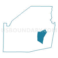
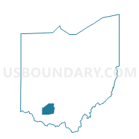
Voting District MARSHALL, Highland County, Ohio
About
Outline

Summary
| Unique Area Identifier | 647941 |
| Name | Voting District MARSHALL |
| County | Highland County |
| State | Ohio |
| Area (square miles) | 22.66 |
| Land Area (square miles) | 21.92 |
| Water Area (square miles) | 0.74 |
| % of Land Area | 96.72 |
| % of Water Area | 3.28 |
| Latitude of the Internal Point | 39.13750860 |
| Longtitude of the Internal Point | -83.47492950 |
Maps

Graphs
Select a template below for downloading or customizing gragh for Voting District MARSHALL, Highland County, Ohio


Neighbors
Neighoring Voting District (by Name) Neighboring Voting District on the Map
- Voting District BRUSHCREEK N, Highland County, OH
- Voting District JACKSON, Highland County, OH
- Voting District LIBERTY S, Highland County, OH
- Voting District PAINT SE, Highland County, OH
- Voting District PAINT SW, Highland County, OH
- Voting District WASHINGTON, Highland County, OH
Top 10 Neighboring County Subdivision (by Population) Neighboring County Subdivision on the Map
- Liberty township, Highland County, OH (10,242)
- Paint township, Highland County, OH (4,585)
- Brushcreek township, Highland County, OH (1,381)
- Washington township, Highland County, OH (1,123)
- Jackson township, Highland County, OH (1,094)
- Marshall township, Highland County, OH (1,029)